
Mingo Property Search, Step by Step
Start at the statewide WV Real Estate Assessment search, often called IAS. It drives most Mingo parcel work. The guided route lets you search by property owner, property address, or parcel attributes. A second path accepts a full parcel ID you already hold. An E-911 address search helps when you know the physical street address but nothing else. For guided parcel work, the county drop-down matters. Choose Mingo before typing district and map details. Each result links to a parcel detail page and a map view. Keep both open while you work the same parcel.
Treat the first hit as a lead, not an answer. Check that the physical address and legal description fit the property in question. Then note the owner, parcel ID, tax year, book and page, and values. An address that misses may still surface through a street-only IAS property-address search. That search can catch text a full address format hides. For owner searches, try initials and name variants. Then confirm any match against the recorded deed. A close name match never proves two entries describe the same person. It never proves the same parcel, either.
- Enter the E-911 address, including town and WV, when the site location is known.
- If no result appears, switch to property-address mode and try the street name alone.
- Record the full parcel ID, owner, mailing address, situs address, legal description, and book/page.
- Compare the same parcel in the WV Property Viewer and its IAS detail page.
- Use the owner or book/page reference in the Mingo County Clerk land-record index.
Use E-911 for Mingo Address Search
The state's E-911 lookup answers to physical addresses, not mailing routes. Enter a street, a city, and the West Virginia abbreviation. Rural routes and post-office boxes will not resolve to an E-911 location. A Williamson or Delbarton mailing line alone cannot tell you where a parcel sits. That matters along valleys where incorporated and unincorporated land share one road corridor. If the complete address fails, switch to street-name mode. Do not pile on punctuation or guess a ZIP boundary.
Two address fields serve different masters in these record systems. The situs address marks where the property actually lies. The owner address marks where the tax mail goes, and it may be a post-office box in another town. Keep both in your notes and compare each against the legal description and the map. That habit prevents a common Mingo error. Reading the city on an owner's envelope as the place where the land sits is the mistake to avoid.
IAS Fields for Mingo Parcels
The assessment search exposes several inputs, and some apply only to a single route. This field list reflects the IAS search itself, not the county clerk's separate grantor-grantee index. Labels can change, so when the screen in front of you differs, follow the live prompt and ask the assessor about any record that will not surface.
| Field or Mode | Use | Required / Format |
|---|---|---|
| County and search type | Guided parcel search | Select Mingo; choose parcel number, property owner, or property address |
| Owner name | Find parcels under a person or entity | Partial text works; LASTNAME FIRSTNAME format is documented |
| Property address | Find by street text | Street name alone may work when full IAS text is incomplete |
| District, map, parcel, suffix | Narrow a parcel-number search | District is required; remaining segments narrow the result |
| Full parcel ID | Open a known parcel | Enter as a continuous number or with hyphens where accepted |
| E-911 address | Locate a situs address | Street, town, state; no rural route or post-office box |
The state publishes no coverage-year promise on the search page. A blank result may reflect a spelling, format, or data issue. It does not always mean a missing land record. Save whatever parcel result you get, then check the clerk's deed reference against it. Open the WV IAS assessment search to use its owner, address, parcel, and county controls.
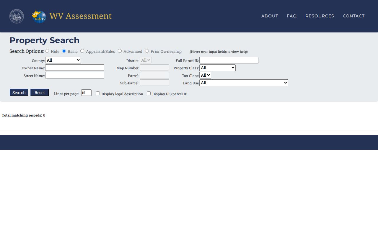
The interface helps you pick a search route, but the result detail still calls for a parcel-level cross-check.
A Street-Only Search Can Find Mingo Records
IAS property-address text can be incomplete. When an exact address returns nothing, drop the house number and search the street name alone. The search may then return nearby records. Their stored spelling or format can differ from the postal label. Review each result's legal description, owner, and parcel ID instead of grabbing the first row. Remember that an address hit is only a navigation aid. It does not prove the parcel sits inside a town limit. Nor does it confirm a particular tax district.
Local geography helps and misleads in equal measure. For Williamson, the Tug Fork and the Kentucky line frame the wider address context. Matewan sits at the meeting of the Tug Fork and Mate Creek. Delbarton stretches along the State Route 65 corridor. Yet a map name settles nothing about boundaries. Mingo planning material names districts including Kermit-Harvey, Tug-Hardee, Lee, Magnolia, and Williamson. Confirm the actual district on IAS or the tax map. Do not infer it from a town name.
Note: A town or ZIP label describes mail service, not a tax district, city line, or parcel boundary.
Fields on a Mingo Parcel Record
An IAS detail page blends several things. It combines the roll owner with parcel identity, a legal description, a clerk reference, and assessed values. A Delbarton sample shows the separation plainly. A post-office box stands in the owner address field. The legal description, meanwhile, identifies fee acreage in George C. Steele Addition. The book and page reference, 626/658, points toward a clerk instrument. It is not a sale price. Nor does it guarantee the present roll owner is the latest grantee.
| Tax year and class | The assessment period and property class displayed for that parcel |
|---|---|
| Owner and owner address | Roll name and mailing address; a map result may show only one owner |
| Book and page | Reference to a clerk record that can be checked in the land index |
| Legal description | Recorded parcel text, which may name an addition or describe acreage |
| Land, building, total | Assessment amounts by year, not an observed market sale price |
| Parcel history and links | Tax-year rows, map view, and assessment report where available |
The sample parcel carries a five-year assessment history covering 2022 through 2026. The 2026 row lists land at $59,500 and the building at $2,980,600. That puts the total appraisal at $3,040,100. The display skips any sale-consideration field. So the price a buyer paid is not part of this view. For a conveyance, read the recorded deed. For what is owed, check with the tax office. Keep in mind that an assessment record falls well short of a full title search. To see all of these fields in one place, view the Mingo sample parcel detail.
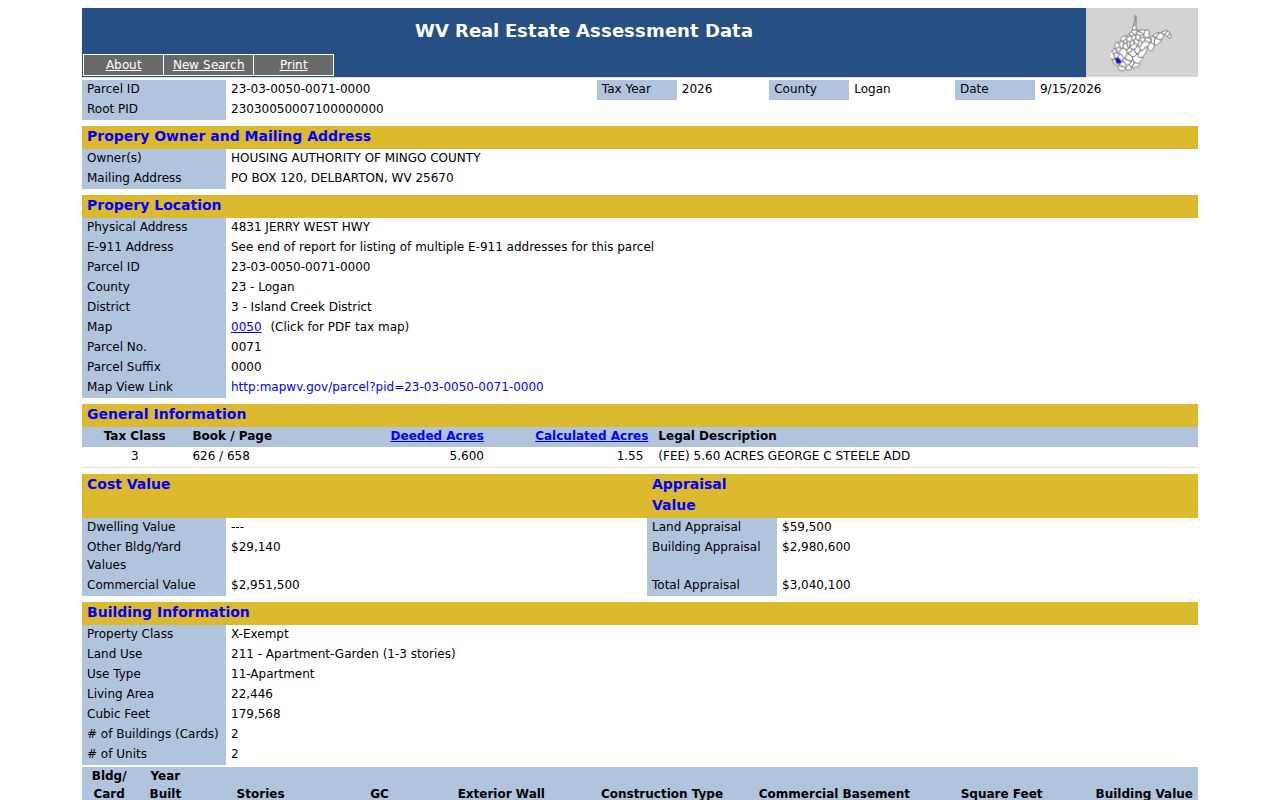
Treat this example as a map of the fields worth capturing, and pull the live detail for the address you are researching.
Owner Search in Mingo Needs Name Variants
The IAS owner field accepts partial text. Start with the surname alone. Add a first initial only if the results come back too broad. Add a full first name on the same condition. Punctuation and spacing variants come later, after the simplest form fails. Title can also sit in unexpected hands. It may be held jointly, through an estate, or under a company or trust name. The WV map viewer sometimes shows just one owner even when the record holds more. So read the assessor detail and the deed's grantee line before concluding that an owner search caught every interest.
An LLC or corporation in the owner field raises its own question. The state business search can reveal the entity's registered agent and filing name. It cannot prove that entity owns a particular lot. The Mingo clerk's deed remains the record that settles ownership of a parcel. Run the owner's exact legal name through the land index. Then use the legal description to rule out similar parcels. Estates add one more wrinkle. Title may appear under a personal representative, or under the decedent's own name. A single search form is too narrow to catch both.
Large Mingo Search Results Need Narrowing
The WV Property Viewer caps any search at 1,000 parcel rows. It pairs that with an Export as CSV control. A broad owner query or a loose map selection can hit the ceiling quickly. Narrow first by county, district, map, street, or a tighter geometry before exporting anything. The CSV is a working list. It is not proof it holds every record a wide query would match. When the list looks oddly short, check the viewer's on-screen limit.
Map results also serve as a way to spot nearby parcel IDs. Hovering a row lights up its shape; clicking zooms in and opens basic information. The drawing tools include Point, Rectangle, Polygon, buffer size, and coordinate searches. If a geometry comes back missing or stacked, drop back to the assessment record. Compare parcel attributes directly there. The GIS clearinghouse carries the tax-map material, though the exact Mingo subfile path deserves confirmation before anyone cites a download as complete.
Choose a Mingo Search Key
Address, owner, and parcel number are not interchangeable keys. Pick the one most likely to land on a single record. Then let the returned parcel ID bridge you into the other systems. A Mingo County property search works best as a sequence. The address finds the assessment record, the parcel ID checks the map, and book/page or party names pull up the recorded instrument. A street-only search has a narrower role. It is a fallback for incomplete IAS text. It is not a substitute for confirming the address on the parcel detail itself.
| Search Key | Best For | Where It Works | Watch Out |
|---|---|---|---|
| E-911 address | Locate a known physical site | IAS and WV Property Viewer | Rural routes and post-office boxes do not work |
| Street text | Recover from an incomplete address match | IAS property-address mode | Review each result; stored text may omit details |
| Owner name | Find parcels tied to a person or entity | IAS owner search; clerk party index for instruments | Try variants; one map owner may omit co-owners |
| Parcel ID | Return to one known tax parcel | IAS and WV Property Viewer | Preserve district, map, parcel, and suffix segments |
Not a title search. A Mingo property search finds assessment and map records, not every interest or legal defect. Confirm the latest deed with the county clerk and use a title professional for a title opinion.
Carry the Search to Mingo Deeds
Once IAS hands you a book and page, stop there. Treat it as the next clue in the Mingo clerk's land-record system. The public landing page names the kinds of instruments recorded. It does not spell out the live index's exact field labels. Earliest online year, image access, and any account terms also go unstated. A name in an index is never a promise that an image waits behind it. Search both grantor and grantee with legal-name variants. If the online route runs out, ask the clerk about an in-person lookup or a copy request.
Know what each instrument actually does. A deed of trust secures a loan; it does not transfer ownership. Releases and assignments track later changes in a lien. Plats and agreements can round out a legal description. For the chain of title, confirm the transfer deed and keep following its grantor backward. This handoff keeps a Mingo property search centered on parcel identification. Deed mechanics, instrument classes, and statutory copy fees belong on the deed records page.